Population and Settlement
Records show that the first inhabitants of Liechtenstein existed in the fifth millennium before the Common Era, also known as the Later Stone Age or Neolithic Age. These people consisted mostly of early farming settlements as the region’s climate was conducive to agricultural production. Although located between the wet, cool climate zone of Lake Constance and the dry, warm Alpine climate zone, Liechtenstein tends to have relatively nice weather due to the warm Föhn wind. “The Föhn wind is a warm, dry katabatic wind that blows through Liechtenstein in certain climatic conditions,” resulting “in an extended vegetation period in the country” (“Climate,” n.d.). In addition, the country receives a low level of annual precipitation that when combined with the warm wind, leads to relatively little snow in Liechtenstein. Moreover, “there are an average of around 1600 hours of sunshine per year” (“Climate,” n.d.). All of these conditions allowed for the early inhabitants to live an agricultural life rather than having to migrate as hunters and gatherers did.
This climate allows for the cultivation of a variety of plants and animals leading to plenty of resources for these early settlers. The unusually warm weather due to the Föhn wind is favorable to the growth of grapes and corn, in addition to a variety of orchid species. Native plants include gentian, alpine rose, and edelweiss that can be found in the higher elevations where it would be common to find such Alpine plant specimens. Additional trees that inhabit the region include the red beech, sycamore, maple, alder, and larch. In addition to the variety of plant life, Liechtenstein is home to an array of animals as well, including the deer, fox, badger, chamois and over 100 species of birds. The region has no extreme natural hazards except the flooding of the Rhine, which provides arable land and hydroelectric potential.
Liechtenstein’s close proximity to the Rhine, a large free flowing river, made for both positive and negative consequences during the settlement of the land. For a long time, the threat of flooding, forced inhabitants to settle only on the upper parts of the valley (“Early History,” n.d.). “For example, there is evidence of a settlement on the hilltop that is home to Gutenberg Castle in Balzers as well as in Eschnerberg” (“Early History,” n.d.). On the other hand, the overflowing waters of the Rhine allowed for fertile lands near the river adding to the great farming conditions. Additionally, “the Alpine Rhine Valley is part of a significant trade route leading from southern Germany over the Alpine passes to the South,” making it easy for many cultures to have influenced the region over time (Government Spokesperson, n.d).
These first inhabitants were Raetians but also included Celtic influences from the west. Raetia was conquered by the Romans in the year 15 BC and was declared a Roman province. The Romans were able to conquer the Raetian tribes because of their army and more advanced weaponry. “In the first century BC an army road connecting Milan and Bregenz was built over the Luzisteig and along the right bank of the Rhine. This road led to the construction of estates and forts in the region occupied by modern-day Liechtenstein” (“Early History,” n.d.). By the 5th century, the Roman Empire had decayed and the majority of the new inhabitants were due to Alemannic immigration (Principality of Liechtenstein, n.d.).
Once the Roman Empire was dissolved, Raetia was incorporated into the Frankish Empire under Charlemagne in the 8th century. Later in the 10th century, Raetia was under the control of the counts of Bregenz, which dissolved in 1152. Through divisions of inheritance, Raetia was divided up into smaller and smaller areas. Lower Raetia was handed down to the counts of Montfort and later divided into Monfort and Werdenberg. Eventually the County of Vaduz, Lichtenstein’s current capital, came from further branching of Werdenberg. “In 1396, King Wenzel validated the Imperial immediacy of the counts of Vaduz,” beginning the process of territorial lordship that would continue to be important in the later settlement of Lichtenstein. (Principality of Liechtenstein, n.d.).
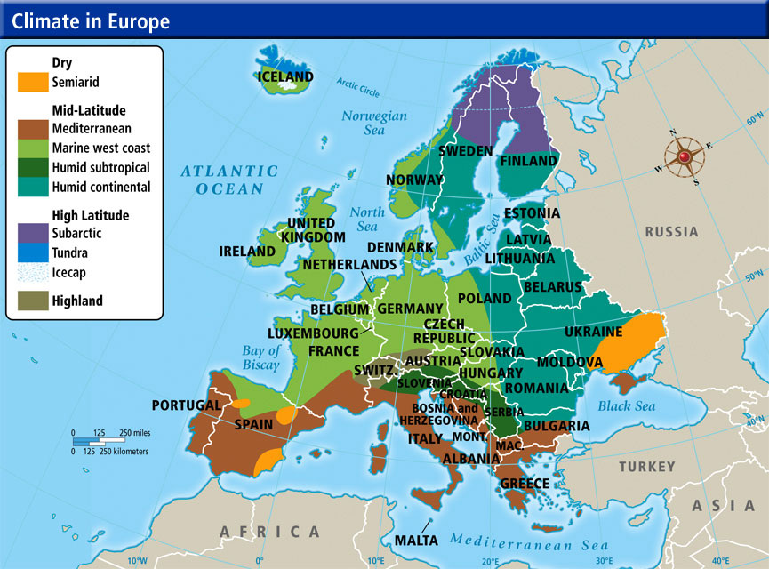
This map shows the different climate zones of the European countries. It illustrates the location of Lichtenstein in between Switzerland and Austria. It is described as a highland climate due to the mountainous region is is located in. Highland climates tend to be fairly moderate yet vary depending on elevation. This climate was conducive to living in the region and existing in an agricultural settlement.
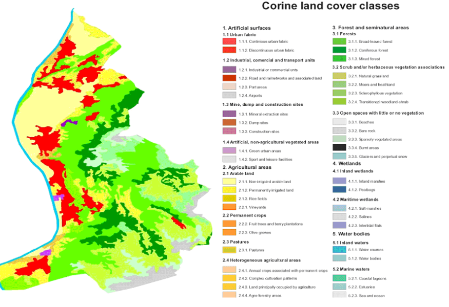
This map shows how the land is utilized by dividing it into different classes of land cover. It illustrates that the majority of the land in Liechtenstein is vegetation, forests, or agricultural areas which is conclusive to the fact that the earliest settlers of Liechtenstein were farmers. This map enforces the statement that conditions in Liechtenstein were and still are conducive to farming.
Additional Information

The Embassy of the Principality of Liechtenstein: This government website provides an accurate, and in-depth history of the settlement of Lichtenstein as well as additional tourism, consular, and embassy information.

Liechtenstein: This official website of Liechtenstein provides a historical summary in addition to up-to-date cultural, educational, and economic data of the country. This is one of the most credible sites for information on Liechtenstein.
Population Pyramids
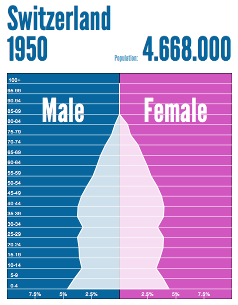
There was not sufficient data on Liechtenstein to create a population pyramid, but the population of the neighboring country of Switzerland remained relatively similar to that of Liechtenstein. This population pyramid shows that the number of children being born remained consistently the same throughout the years leading up to 1950 and continuing into that year. The average life span was approximately 55 years old at this time, as represented by the declining size of pyramid near the top. Both sides are nearly equal meaning men and women comprised about the same percentage of the population in 1950.
Source: Populationpyramid.net
|
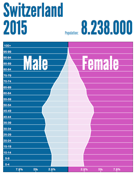
There was not sufficient data on Liechtenstein to create a population pyramid, but the population of the neighboring country of Switzerland remained relatively similar to that of Liechtenstein. This population pyramid illustrates that the birth rate dropped significantly by this time as shown by the smaller bottom of the pyramid. The average life span had increased by this time to about 70 years old. Men and women still comprised nearly the same percentage of the population in 2015.
Source: Populationpyramid.net
|
Sources
Climate in Europe[Map]. (n.d.). Retrieved September 14, 2014, from http://westshore.hs.brevard.k12.fl.us/teachers/sarverr/page3.html
Corrine Land Cover Classes[Map]. (2002). Retrieved September 14, 2014, from http://www.eea.europa.eu/soer/countries/li/land-use-state-and-impacts-liechtenstein
Government Spokesperson. (n.d.). Archeology. Retrieved September 8, 2014, from https://web.archive.org/web/20071020182701/http://www.liechtenstein.li/en/eliechtenstein_main_sites/portal_fuerstentum_liechtenstein/fl-kuk-kultur_kunst/fl-kuk-staat/fl-kuk-staat-archaeologie.htm
Lichtenstein Marketing. (n.d.). Climate. Retrieved September 7, 2014, from http://www.liechtenstein.li/en/country-and-people/geography/climate/
Lichtenstein Marketing. (n.d.). Early history. Retrieved September 10, 2014, from http://www.liechtenstein.li/en/country-and-people/history/early-history/
Principality of Lichtenstein. (n.d.). History. Retrieved September 7, 2014, from https://web.archive.org/web/20070926224445/http://www.liechtenstein.li/en/pdf-fl-lik-geschichte-03_geschichte.pdf
The River Rhine in the Principality of Liechtenstein. (2005). Retrieved September 16, 2014, from http://www.about-liechtenstein.co.uk/history/geographic/rhine.html
